


 01.40
01.40
 ucok
ucok


History
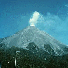
Merapi Volcano which located on 2968 meters above sea level altitude is the most active volcano in Indonesia and one of the most active volcanoes in the world. Berthomier, a French academician, divided Merapi development into four stages. The first stage is Pre-Merapi (until 400.000 years ago), that is Mount Bibi which its part still can be seen from the east side of Merapi peak. Old-Merapi stage happened when Merapi was started to formed but not yet conical (60.000 – 8000 years ago). The remnant of this stage is Turgo Hill and Plawangan Hill in the south, which is formed from basaltic lava. The next stage is middle Merapi (8000 - 2000 years ago) signed by formation of high peaks, like Gajahmungkur Hill and Batulawang Hill, which is composed of andesite lava. The type of Merapi activity is effusive (melt) and explosive eruption.

Specialty
The beauty of Merapi Volcano natural enchantment is not indisputable. This mountain which is surrounded by beauty combined with mystery will be able to seen clearly –if the weather is not foggy— standing upright from four surrounding cities: Sleman, Magelang, Klaten, and Boyolali. Its fresh air and its warm hospitality of the people around are parts that can’t be separated from this mountain –which when in the normal status— used to be climbed by many tourists until its peak.

Hence, after the 2010 big eruption, some things are changed in this area, but those are not reduced –it’s even enhance— the enchantments of the volcano. Villages which located on 4 to 6 km from the peak are no longer able to inhabited and replaced with a lot of Hunian Sementara/Huntara (Temporary Dwelling) for the refugees who lose their houses. Some bridges are still broken caused by volcano mud flood or volcanic gas hit.
The area of former 2010 eruption is now used by local people as volcano trekking tourism area, where the tourist could really do the path trail of 2010 big eruption, include visiting the former house of Mbah Maridjan, the very famous abdi dalem (caretaker) of Merapi Volcano. There are two former villages which are now become the volcano trekking tourism area: Kepuharjo village and Kinahrejo village. Both villages are maintained by the local residences of those two villages. They even wear T-shirt with the name of the village written on it. On both tourism areas, the tourist could see the former of the 2010 eruption. In Kepuharjo village which more hit by volcanic mud flood, the area is buried by volcanic material, it makes it hard to identify that this area is previously a residence village. While in Kinahrejo, which more hit by volcanic gas, it’s relatively still can be seen the remains of collapsed former residence houses. Nevertheless, in those two villages, new sprouts have been started to grow among the remains of burned and withered plants. Some villagers rent ojek services (motorcycle rental including the driver) for the tourist to go uppers, in case they are lazy to walk. Some others are selling snacks and soft drinks, as well as various souvenirs like the 2010 big eruption CD and T-Shirt with picture of Mbah Maridjan face on it. There is also an information centre there which is always ready to give all the information related to Merapi Volcano. The tourists can see by themselves how terrifying the effects of the 2010 big eruption, and in front of Mosque beside former Mbah Maridjan house (which now are already semi permanent rebuild), lied the pictures of Mbah Maridjan house and surrounding before and after the 2010 big eruption. And please don’t forget to enjoy the culinary jadah tempe, nasi pecel (pecel rice), and wedhang gedhang (banana drink), and some other typically Merapi slope area foods and drinks.
If Merapi status is already stated as normal for climbing, you can climb this mountain via Pronojiwo route, in Kaliurang (after the 2010 big eruption, the climbing route is diverted to Pronojiwo hill) with an excellent challenge and landscape. Observing mystery as well as beauty of incandescent lava of the mountain which is the source of inspiration and life for its surrounding people will be the most unforgettable experience. It’s better to start the climbing in early morning so that you can see the sun rise which spread its shine to the full of legend, elegant, and dignified mountain. This activity of going along Merapi Volcano ridge and slope will take time of about 5 hours.

Location and Facility
Merapi located in the middle of Java islands, at 7”32.5’ south latitude and 110”26.5’ east longitude. The south slope of Merapi Volcano is administratively included in Sleman district, Yogyakarta, and the rest are included in the region of Central Java Province; Magelang district in the west side, Boyolali district in the north and east side, and Klaten district in the southeast side. The forest area around its peak has become Merapi Volcano National Park area since the year of 2004. Magelang and Yogyakarta are the nearest big cities with Merapi peak, have distance of below 30 km from its peak. In its slope, there are still villages until altitude of 1700 m and only has distance of four kilometres from the peak (after the 2010 eruption, that area is emptied, except in some sides).
Merapi Volcano is a popular climbing object, since this mountain is very magnificent. Previously, the most popular and the nearest climbing route is via the north side from Selo, Boyolali district, Central Java, exactly in Tlogolele Village. This village located between Merapi and Merbabu mountains. That via Selo climbing will take time of about 5 hours to reach the peak. The other alternative routes are through the northwest side start from Sawangan, Magelang district, Central Java and through the southeast side, from the way to Deles, Kemalang subdistrict, Klaten district, Central Java. Nevertheless, after the 2010 big eruption, most of climbing routes are diverted through Pronojiwo hill, Kaliurang village, Pakem subdistrict, Sleman district, Yogyakarta in the south side. This route is more precipitous and takes time of about 6 to 7 hours to reach the peak.
The ticket price to enter Kinahrejo and Kepuharjo volcano trekking tourism area is each Rp. 5000, - per person plus parking cost of Rp. 2000, -. While the ojek rental cost from Kinahrejo to former Mbah Maridjan house is Rp. 20.000, - and from Kepuharjo to Kaliadem is about Rp. 35.000, - to Rp. 50.000,-.

 Posted in: Merapi Volcano

0 komentar:
Posting Komentar